URYC Members. Whether you are new to cruiser ownership or inexperienced in terms of sailing beyond the River Crouch, this short article is for you. For the more experienced this article contains links to the latest charted depths for the Raysand Channel and confirmation ‘the Haggerty trench’ (as named by Gerry) does exist!
Introduction
The nearest and, some say, nicest river in Essex, is the River Blackwater. The snag is getting there. The classic route, making best use of the tides, means the entrance to the Blackwater is 17 miles away from the mouth of the Crouch as it entails sailing via the Swin Spitway. So why not take a shortcut and just sail 9 miles instead? The Raysand Channel offers a shorter trip all within sight of land and is far simpler to navigate.
Assuming to have a fair wind and nice conditions (why would you go otherwise) this route is a good introduction to simple coastal pilotage and doesn’t require a fancy chart plotter. Indeed, assuming you have a chart and compass, all you need is a depth sounder.
Example 1
Getting to the Blackwater in good time for a meal ashore or enjoying a pint at Bradwell Marina:
This trip is practical in summer to do when high water times between 12.00 and 16.00hrs. ie during times when it is less practical to take the ‘classic route’ via the Swin Spitway.
Leave your URYC mooring soon after your boat floats on the incoming tide i.e. 3 to 4 hours before HW. As the tide is against you, assume you might use your engine to motor sail to keep up an average of at least 4 knots over the ground.
Timing: you want to be opposite Burnham Marina in 2 hours and the entrance of the River Roach in 2.5 hours. After 3 hours (preferably before high water) you should be sailing just beyond the entrance of the River Crouch on the north side of the Whitaker Channel and then sail progressively more northward in an arc over the sand, simply watching your echo sounder.
You are looking to keep in a minimum depth of water equating to the draft of your boat plus 2 metres. The more confident might say plus 1 metre, but first timers will prefer a bigger margin.
Cutting across the sands
You can stay very safe and skirt along the edge of the Dengie Flats, ticking off passing the beacons on the two pairs of ancient target barges. The tide will be with you until you get to the most Northerly of these beacons. At this point you will begin to feel the effect of the ebb tide coming out of the Blackwater. This is best mitigated by staying in 2 – 3 metres of water over St Peters Flats, rather than straying too far into deeper water.
As you approach Bradwell Power Station you will see a line of small orange buoys off the coast, stay outside of these and continue into the Blackwater in about 3 metres of water. You may need your engine to push you over the tide which will be flowing against you. Time your arrival at around 2 to 2.5 hours after High Water (Burnham).
At this state of the tide, the lazy skipper can ignore most of instructions in his pilot book regarding entering Bradwell Creek and just stick with a depth of 3 metres before intersecting the line of red can buoys marking the entrance channel and then turning into the creek looking to pass the green buoy close to starboard. From there follow the channel by remaining close to the line of moorings to the marina.
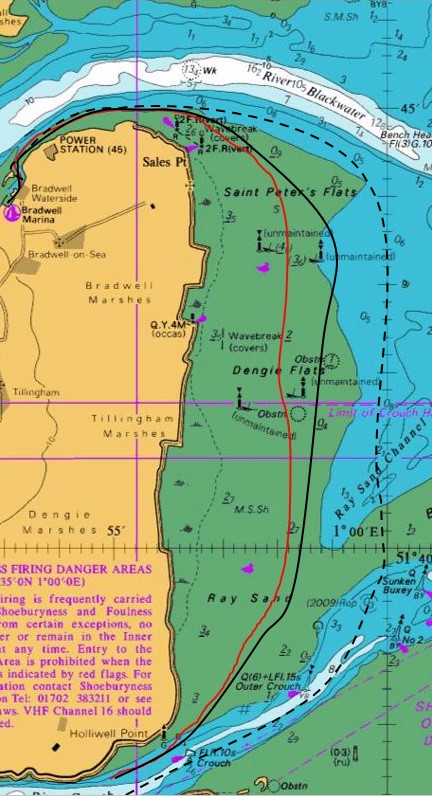
Key
Black line = route described in Example 1 above.
Red line = an actual route following 2m actual depth in smooth conditions
Dashed line = return route described in Example 2 below
Example 2
Returning from the Blackwater via the Raysand Channel. You are looking to get back to your mooring at High Water Hullbridge or no more than one hour after HW.
Say you are in Bradwell Marina or, for a quiet night, have picked up a vacant buoy in Bradwell Creek before heading back to the Crouch the next day. This is a practical example on a day when high water times (Burnham) are typically between 13.00 and 17.00hrs.
Plan
Leave Bradwell Creek one hour after low water, this means you will lift clear if you touch (its shallowest near the northern end of the approach channel). Once beyond the entrance beacon, stick to the edge of the deep water to avoid the worst of the flood tide.
Don’t be tempted to cut across St Peters Flats, keep going generally east until there is at least 3 metres of water under your keel before turning and making your way into the Raysand Channel. You should aim to get to the shallowest part of the Channel no earlier than 3 hours before High Water (Burnham).
There are three buoys that mark the channel. However, they are not in the deepest water. You should pass the first buoy (Raysand North) 100 metres to starboard. The flood tide will take you sideways (ie to the West), consciously counteract this to stay in the deepest water and leave the centre buoy nearer 200m to starboard. You will do better to head for the large Buxey No2 buoy and leave the Yellow (Raysand) buoy 100 metres to Starboard.
Those with a plotter should follow the 001°00’00E meridian.
‘Haggerty’s Trench’
It’s easy to think cutting the corner will save time. In a very shoal draft boat in calm conditions this is possible. However, the deepest water (affectionately christened ‘Haggerty’s Trench’ by Gerry) is found passing to the East of these buoys as described.
Turn toward the West only when are in the Whitaker Channel and have cleared the sands with 4 metres or more under your keel. You should expect to take at least 2.5 – 3 hours to get back to Hullbridge. For most boats under sail, with a favourable wind, you should arrive between high water and one hour after high water.
If the wind is strong from the West, stopping overnight in the Roach or in Burnham Marina makes more sense than battling to get back to URYC the same day. In these conditions, those with powerful diesels might be able to keep up the pace and still return to their mooring nearer to high water.
Resources
I highly recommend the following web site and the detailed charted depths and navigation tips for the Raysand Channel.